What is Natural Flood Management?
Natural flood management, or NFM, aims to replicate natural processes to reduce flood risk, even if this means increasing flood risk locally.
NFM does this in three ways:
- Temporarily storing water during times of heavy or prolonged rainfall then releases it after the storm
- Desynchronises flood peaks
- Reducing surface runoff into the river
There are lots of different types of NFM, such as bunds, woodland planting, peat restoration, but here, we’re going to focus on leaky dams.
Leaky dams (also known as leaky wooden dams, leaky debris dams, engineered log jams) are when wood is added to the river system and is often fixed in place. Some dams can be more natural, where a tree is felled in place, sometimes attached to the stump as a ‘living feature’. Other dams are much more engineered, tied down and anchored in place.
Leaky dams can have a variety of benefits to the river:
- Reconnecting the river to the floodplain during high flows
- Allowing low flows to pass underneath the dam
- Capturing and storing sediment
- Increasing biodiversity in the area
Not all dams are made the same and come in different shapes and sizes! Some have gaps, some extend beyond the river channel, some get blocked and maintained, others don’t.
Here we provide you with examples of leaky dams from around the UK to explore.


Select a location to continue
Dalby Forest
Dalby Forest is a managed woodland in North Yorkshire. As part of the Thornton Villages demonstration project, 12 leaky dams have been installed in the forest to capture sediment as well as display a more natural leaky dam design.
The upstream and downstream sites below are regularly monitored to see how the dams are influencing sediment storage and erosion. We often assume that rivers don’t change shape (geomorphology) when thinking about flood risk management, but that’s not true. When the shape of a river changes, the flood risk changes, for better or worse. It’s important we understand the river’s geomorphology and what impact dams are having on it.

Upstream Staindale Beck
Key Information
- Installed in February 2020 as a living feature
- Monitored by the Energy and Environment Institute since July 2019 (pre-installation monitoring)
- Effectively stores fine grained sediment upstream
- Has resulted in plunge pools and gravel bars forming downstream
- Accumulates wood during high flows
- 3D model captured with iPad Pro LiDAR unit
Downstream Staindale Beck
Key Information
- Installed in February 2020 as a living feature
- Monitored by the Energy and Environment Institute since July 2019 (pre-installation monitoring)
- Has not been activated during monitoring period as too high (or there hasn’t been a large enough rainfall event)
- Low influence on the river geomorphology (if any)
- 3D model captured with iPad Pro LiDAR unit
Visit the field site
Navigate through Dalby Forest exploring one of the field sites we are monitoring. Lookout for information points where you can learn more!
For maximum immersion, we recommend using a mobile phone which will allow you use look around more naturally.
Bridestones SSSI
Key Information
- 12 dams installed in 2018 as part of the Derwent Villages demonstration project
- Dams are in a tributary of Staindale Beck
- 3D model captured with a DJI Mavic 2 Pro drone
As part of a PhD project at the University of Hull, this area is being used for numerical (computer) modelling. This allows us to understand how the dams impact the flow of water and sediment transport, so we can estimate how they perform over time. These dams are quite small, but accumulate leaf litter, water and sediment during high flows. It is important that we can capture this information in numerical models, and we can expand this to other areas in the future. For more technical information, please see here (warning – technical!).
Brighton
Approximately 15 miles north of Brighton there are a series of leaky dams installed on Cob Brook. There are a mixture of engineered designs as well as naturally forming log jams.
These dams are being monitored by the University of Brighton to assess their impact on the flow regime, sediment transport and geomorphology.
Fine grained sediment has accumulated upstream the dams, and a plunge pool developed downstream.
Pickeridge Farm – Upstream
Key Information
- Engineered cross-member type of leaky dam
- Sediment stored upstream of the dam
- Stepped morphology (look at the difference in water surface on the 3D model)
- Leaf and woody debris stored upstream of the dam
- 3D model captured with the iPad Pro
Pickeridge Farm – Downstream
Key Information
- Engineered leaky dam, potentially previously a cross-member type
- Sediment stored upstream of the dam
- Stepped morphology, similar to the upstream dam, though more pronounced
- More leaf and woody debris stored upstream of the dam
- 3D model captured with the iPad Pro
Pickeridge Farm – Naturally Formed
Key Information
- Naturally formed leaky dam, likely due to tree which has fallen into the river
- Example of feature leaky dams are trying to replicate – note similar patterns with wood and leaf litter storage as well as sediment storage
- Depending on the flow direction, wood can encourage erosion – see the bank erosion in the 3D model
- 3D model created with Structure-from-Motion
Nottingham
Near Nottingham Trent University in Southwell, a river restoration project was carried out to re-introduce a natural river and remove a straightened system. Rivers are often straightened to encourage water to flow through them more quickly reducing local flood risk, however this can increase flood risk downstream. Urban or ‘high-value’ areas are often straightened because of this. In addition, a leaky dam was installed downstream and monitored as part of a (completed) PhD project by Dr Josh Wells and Dr Jillian Labadz
The dams have accumulated sediment and woody debris, limiting flow under the structure. The stream is not always flowing however (it is ephemeral) and only flows during rainfall.

Southwell Large Dam
Key Information
- Large dam installed in an ephemeral stream
- Two main logs in a small gulley
- Sediment and leaf debris captured behind the dam, previously there was a gap between the bottom of the dam and the river bed
- Small plunge pool immediately downstream of the dam
- 3D model captured with iPad Pro
Southwell Small Dam
Key Information
- Small (less than one metre) dam installed in ephemeral stream
- Dam installed touching the gully bed
- Not active very often before this survey, no leaf litter trapped behind the dam
Hebden Bridge
North of Hebden Bridge is Hardcastle Crags, a National Trust owned wooded valley where volunteers have been installing leaky dams since 2016 to intercept water flowing over the steep valley sides during heavy rainfall.
You can read more about the site here.
There are lots of different types of leaky dam installed here. They are mostly found on the sides of the valley to reduce connectivity from surface runoff to the main river, rather than being installed in the river itself.
Leaky Dam Example
Key Information
- An example of a small leaky dam installed between two rocks, a likely pathway that water will use to flow down during times of rainfall
- Looking at the dam from the side, there is a distinct difference in the height of the soil. This is most likely because the dam has trapped sediment during heavy rain
- Think about what this could mean. If the dam has trapped all of the sediment and can’t store any more, what will happen next time it rains? The water will likely choose another route (to the left of the dam), or the dam will be less effective as water will simply flow over the top
- It is important that we understand how the dams impact geomorphology and trap sediment so we can see how their effectiveness changes over time
- 3D model created with Structure-from-Motion
Eden
Within the River Eden catchment are a series of leaky dams, from small to large, installed to reduce flood risk. You can find out more information here.
The leaky dams installed here generally consist of two logs on top of each other, connected by metal rope and are anchored in place. They allow low flows to pass beneath them and should activate during high flows.
Leaky Dam Example
Key Information
- Small dam
- Anchored in place
- Example of a scale bar in the model used for scaling
- 3D model created using Structure-from-Motion
Experience Dalby Forest in 360
Put yourself in the heart of Dalby Forest and listen to a river soundscape.
Play on a phone or with a headset for maximum immersion.
More coming soon.
Funded by

More Recent Projects
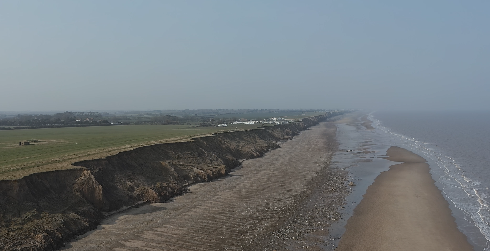
The Holderness Coast
The Holderness Coast The Holderness Coast is one of world’s fastest receding coastlines with an annual average erosion rate of two metres per year and is highly geomorphologically active. Coastal…
Flood Stories
Immersive Storytelling for Education and Action. Exploring children’s experiences of flooding using 360 technologies.
